NSL – Netzwerk Stadt und Landschaft ETH Zürich
  • Projects
      • Projects of the Chairs
        • Prof. Dr. Bryan T. Adey | Infrastructure Management
        • Prof. Dr. Tom Avermaete | History and Theory of Urban Design
        • Prof. Dr. Kay W. Axhausen | Traffic and Transport Planning
        • Prof. Dr. Francesco Corman | Transport Systems
        • Prof. Teresa Galí-Izard | Chair of Being Alive
        • Prof. Dr. Adrienne Grêt-Regamey | Planning of Landscape and Urban Systems (PLUS)
        • Prof. Dr. Eva Heinen | Transportation and Mobility Planning
        • Prof. Dr. David Kaufmann | Spatial Development and Urban Policy
        • Prof. Hubert Klumpner | Architecture and Urban Design
        • Dr. Anastasios Kouvelas | Traffic Engineering and Control
        • Prof. Dr. Christian Schmid | Sociology
        • Prof. Milica Topalovic | Architecture and Territorial Planning
        • Dr. Jennifer Duyne Barenstein | ETH Wohnforum – ETH CASE
        • NSL-Archiv
      • Former Chairs
      • NSL Colloquia – The NSL Colloquia are a bi-annual presentation of exceptional work under a rotating theme determined by the inviting professor.
      • NSL Projects
          • E-Bike City
          • Future Cities Lab Global
          • Urban Potential and Strategies in Metropolitan Territories
 – The Zurich Metropolitan Region as an Example (NFP65)
          • Large-scale Virtualization and Modeling Lab (LVML)
      • NSL Forum
        • NSL Forum & Cycling Research Board
        • NSL Forum: Pandemie? Mitten im Klimawandel. Was bedeutet das für die räumliche Entwicklung der Schweiz? Ein Dialog.
    Close
  • Teaching
    • Teaching
      • Bachelor and Master Degree Programmes, Department ARCH
      • Bachelor and Master Degree Programmes, Department BAUG
      • MSc in Spatial Development and Infrastructure Systems
      • MAS/CAS in Regenerative Materials
      • CAS in Regenerative Systems: Sustainability to Regeneration
      • MAS/CAS Spatial Development
      • MAS Urban and Territorial Design
      • MAS in Housing
      • Doctoral Programme in Landscape and Urban Studies
      • The teaching component of the NSL seeks to impart the knowledge and skills needed to develop the standard strengths of spatial planning and their interaction as well as the ability to develop strategies for the solution of spatial problems. These are central prerequisites for a responsible and successful exercise of planning functions in the service of the public commonwealth and of private companies. Especially important in fufilling these prerequisites is the quality of university-level education: graduate and post-graduate work as well as professional development in spatial, urban and landscape planning. The ETH Zurich has offered programmes such as continuing education courses and post-graduate programmes (NDS, now MAS) since 1965. The NSL (Network City and Landscape) is responsible for these courses and programmes.
    Close
  • Publications
    • Cover NL 65NSL Newsletter – The NSL brings the experts at ETH Zurich together and also maintains a dialogue with other groups that deal with or are interested in issues relating to cities and landscapes.
    • A map describing the different phases of India’s neoliberal highway programme. Source: The author.Publications of NSL Chairs – A complete list of publications can be reached via the following link, which also includes advanced search capabilities:
      • ETH Zürich Research Collection
    • disP – The Planning Review – The interdisciplinary scientific journal covers the topics of spatial development, urban planning, landscape and environmental planning, landscape architecture, traffic planning, and regional and environmental economics, as well as special issues on specific themes.
      • Instructions for Authors
      • Types of Articles
      • Publisher
      • Book Review Guidelines
      • Editorial Staff
      • Latest Issue
      • facebook
    • DELUS Cover Issue 1DELUS – Journal for Landscape and Urban Studies – DELUS is an annual publication by the Institute of Landscape and Urban Studies at ETH Zürich.
    Close
  • News
  • Contact
      • en
        • de
        • fr
        • it
      • Search

    • Close
      • en
        • de
        • fr
        • it

Was uns historische Verkehrskarten verraten

Die Frage, wie sich besser ausgebaute, weiter verzweigte und schnellere Verkehrswege auf den Raum, die Gesellschaft und die Wirtschaft auswirken, stellt sich in regelmässigen Abständen ganz konkret. Immer dann, wenn wieder grössere Investitionen in unser Verkehrssystem anstehen. Doch was für Auswirkungen sind zu erwarten? Können wir aus der Geschichte lernen? 

Seit Jahrhunderten wird an Europas Verkehrssystem gebaut. Die Erreichbarkeit verschiedener Gegenden und Landstriche hat sich dadurch immer wieder verändert – gewisse Regionen rückten näher zu einander, andere von einander weg. In dem Zusammenhang rekonstruiert Raphael Fuhrer, Doktorand am IVT, das Verkehrsangebot Westeuropas von 1500 bis heute, um diese Entwicklung in Zahlen fassen zu können. Rückgrat dabei ist ein historisches geographisches Informationssystem (hGIS).

Wer mit historischem Material arbeitet, merkt schnell: man muss flexibel sein. Mit Das ist der Rom-Weg von meylen zu meylen mit puncten verzeychnet von eyner stat zu der andern durch deutzsche lantt schuf um 1500 Erhard Etzlaub in Nürnberg eine Reisehilfe für alle, die von Nordeuropa nach Rom wollten. Der Reiserichtung entsprechend, steht die Karte auf dem Kopf und erschwerend kommt hinzu, dass eine akkurate Projektion fehlt. Eine solche etablierte sich erst knapp 100 Jahre später mit Mercator. So entstanden erst ab dem 17. Jahrhundert Karten, die mit unseren heutigen vergleichbar sind. Damals war der Erwerb einer Karte eine Investition und die Karte sollte eine Weile ihren Dienst erfüllen. Änderungen in Gebietsansprüchen machten jedoch neue Auflagen notwendig.

Netze folgen Netzen

A new map of the seat of war in the Netherlands vom 12. Mai 1794, vertrieben durch Robert Laurie & John Wittle in 53 Fleet Street in London, ist so ein Beispiel. Was damals Niederlande hiess, ist zu grossen Teilen das heutige Belgien. Die feinsäuberlich eingezeichneten Wege zeigen eine wichtige historische Konstante auf: Netze folgen Netzen. Viele damalige Wege folgten früheren Wegen oder bereits zuvor schiffbaren Flüssen und Kanälen. Auch wird sichtbar, dass im damaligen Europa jedes Land seine eigenen Längen- und Zeitmasse verwendete. Die Reisezeit ist aus verkehrshistorischer Sicht eine der wichtigen Kenngrössen. Es ist klar, dass damals Reisen sehr viel Zeit in Anspruch nahm. Die Schätzungen stützen sich neben der Streckenlänge auch auf die Verfügbarkeit von Verkehrsmitteln.

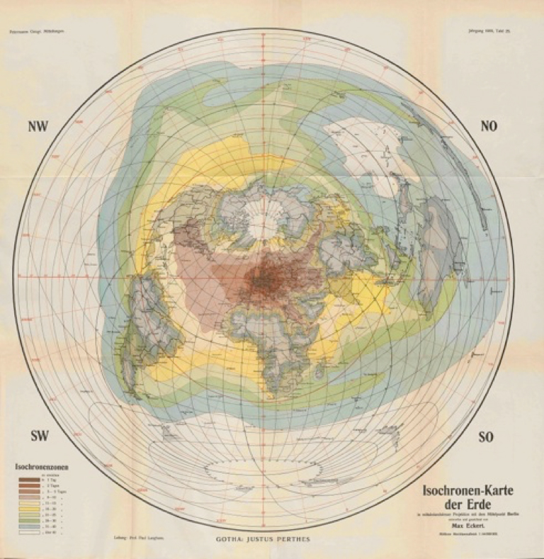
Die Postkutsche war vor der Eisenbahn das Verkehrsmittel schlechthin. Die Veränderungen im Streckennetz über die Jahrhunderte lassen sich recht gut nachvollziehen. Die Routes des postes d’Italie, 1705 zusammengestellt von Nicolas de Fer, zeigen exemplarisch das Netzt im damaligen Italien. Die Schweiz war von Genf via Savoyen, von Brig über den Simplon und von Bellinzona über Lugano nach Como mit Norditalien verbunden. Mit Hilfe von damaligen Aufstellungen zu Tarif, Etappen – so genannte Posten – und Kutschenart lassen sich historische Reisezeiten des öffentlichen Verkehrs ausmachen. Max Eckert verdichtete 1909 solche Angaben in seinem Aufsatz zu seiner «Isochronen-Karte der Erde in mittabstandstreuer Projektion mit dem Mittelpunkt Berlin». Unter den verfügbaren Verkehrsmitteln wählte er jeweils das schnellste aus und konnte zeigen, dass vor hundert Jahren praktisch ganz Europa binnen fünf Tage von Berlin aus erreichbar war.

Raphaël Fuhrer ist Doktorand am IVT und beschäftigt sich mit den Auswirkungen von Verkehr auf den Raum in Bezug auf Gesellschaft, Wirtschaft und Umwelt. Er arbeitet dazu häufig mit historischen Daten.

Share this...
  • Facebook
  • Linkedin
  • Whatsapp
  • Email
This article has been published in the following newsletter edition:

33 | März 2017: Ein Blick zurück

  • Das Wissen von der Stadt
  • Die Landschaft lesen
  • Was uns historische Verkehrskarten verraten
  • Backcasting – Looking Backwards to Reach the Desired Future
  • Pathways of Post-Socialist Urban Development. The Case of Budapest
  • «Prof. Milica Topalovic: What is Territorial Planning?»
  • Mapping Urban Ecosystem Services with Google
Kurzmeldungen
  • The People’s Museum
  • ETH Zürich am WEF 2017 in Davos: «Magic through Technology»
Publikationen
  • Architecture Competition: Project Design and the Building Process.
  • Investigation of a static and a dynamic neighbourhood methodology to develop work programs for multiple close municipal infrastructure networks
  • Delta Dialogues. Heft Nr. 20 der Schriftenreihe «Pamphlet»
  • Extending Morris method for qualitative global sensitivity analysis of models with dependent inputs
  • Estimating pedestrian speed using aggregated literature data
  • Der intelligente Parkplatz: Elektronisch gesteuertes, dynamisches Preissystem

Chairs

Prof. Dr. Bryan T. Adey
Prof. Dr. Kay W. Axhausen
Prof. Dr. Tom Avermaete
Prof. Maria Conen
Prof. Dr. Francesco Corman
Dr. Jennifer Duyne Barenstein
Prof. Teresa Galí-Izard
Prof. Dr. Adrienne Grêt-Regamey
Prof. Dr. Guillaume Habert
Prof. Dr. Eva Heinen
Prof. Damian Jerjen
Prof. Dr. David Kaufmann
Prof. Hubert Klumpner
Dr. Anastasios Kouvelas
Prof. Freek Persyn
Prof. Dr. Christian Schmid
Prof. Milica Topalovic
Prof. Martina Voser

Contact

Address
ETH Zürich
NSL – Netzwerk Stadt und Landschaft
Stefano-Franscini-Platz 5
HIL H 44.2
8093 Zürich

NSL Director
Director: Prof. Dr. David Kaufmann
Deputy Director: Prof. Milica Topalovic

NSL Coordination
Claudia Gebert
Telephone: +41 (0)44 633 36 33


Register for the NSL Newsletter

disP Publication Office

Editor-in-Chief
Dr. sc. techn. Martina Koll-Schretzenmayr, Spatial planner ETH/NDS,
Telephone +41 (0)44 633 29 47

Mailing address
ETH Zürich
Redaktion disP
NSL – Netzwerk Stadt und Landschaft
Stefano-Franscini-Platz 5
HIL H 33.3
8093 Zürich
Fax +41 (0)44 633 12 15
E-Mail


NSL Archive (gta)

Research and Bequest Archive for
Swiss Landscape Architecture and Spatial Planning

Consultation Requests

Mailing address
ETH Zürich
NSL Archive (gta)
Stefano-Franscini-Platz 5
HIL C 65.2
CH-8093 Zurich


Privacy Policy